Feeds:
Posts
Comments

Archive for August, 2015

Brenda Goeden of BCDC and Ian Wren SF Bay Keepers joined us on August 19th, 2015 at the Exploratorium to to talk about what gets dredged out of the San Francisco Bay.

Most of the dredging that goes on in the bay is for navigation. This is mostly through mud — 80% of the Bay is fine grain mud, and it is dug out to allow deep draft vessels to come through, and keep waters by marina’s clear. The dredging aka mining of sand is mainly for the construction industry – it becomes cement, asphalt, road-base, sub-base and general fill. The grains of sand are grains (.002 to .08 inches in diameter) bigger than mud, and smaller than gravel. it gets mined on demand, not necessarily day in, day out.

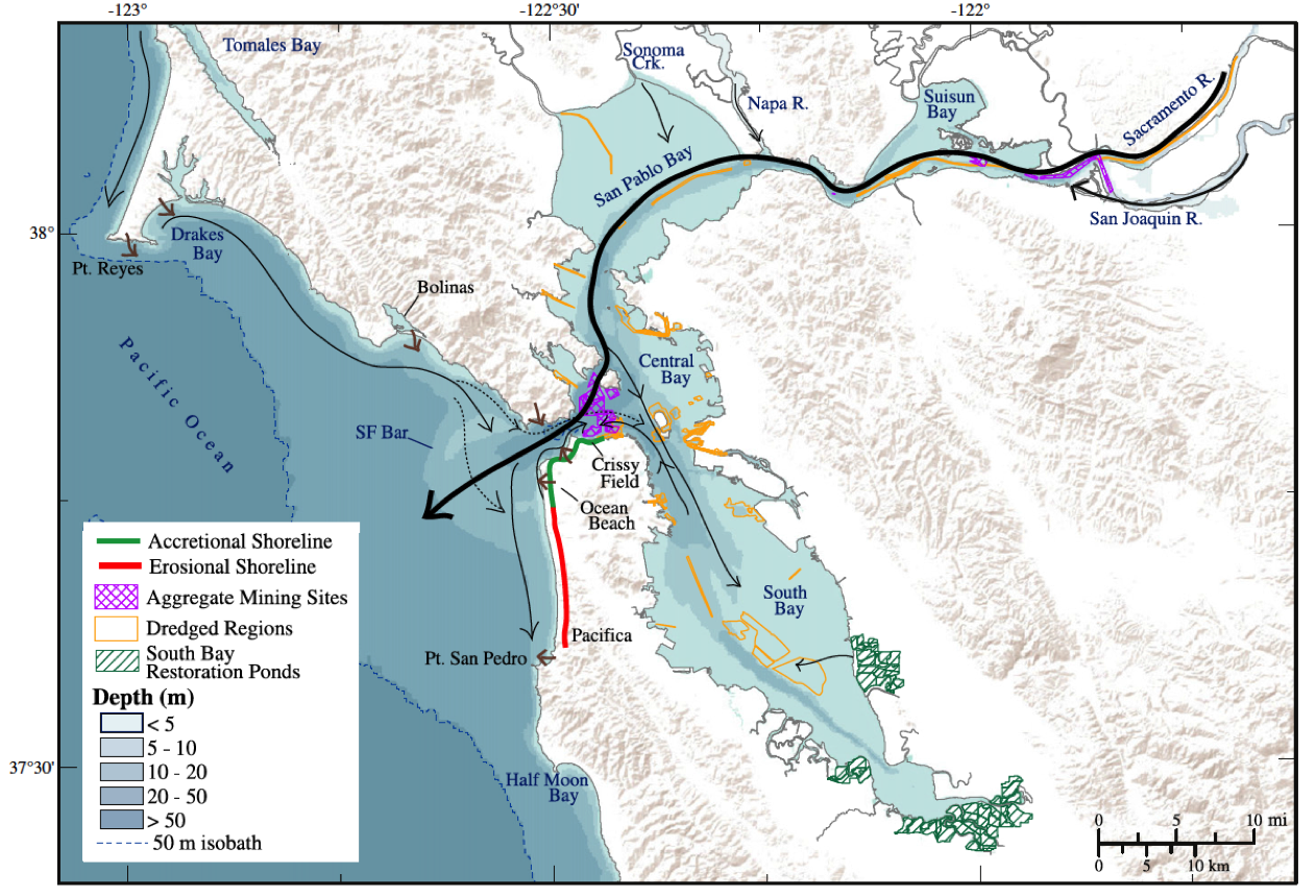
There are two main areas whether the sand comes from: Suisun Bay and the Central Bay. Suisun Bay is a finer grain of sand which is often used for back fill in trenches. The coarser sand of the the Central Bay is used for cement. Sand is only found in the high flow areas of the Bay where the water has enough energy to carry the sand. Mud is taken out to the slow wide sides of the Bay.

Sand Flow in the Bay - Barnard et al. 2013

Sand is important for a number of reasons outside of its commercial uses — it helps build marshes and beach. It provides shoreline protection as it takes more energy to move, it provides a particular kind of habitat, and on the shore provides a place for recreation and having a place for viewing wildlife.

The amount of historical sand, and sand in the Bay is difficult to measure. Most of the sand in the Bay comes from the Delta and the larger watershed (40% of California’s watershed drains into the Bay), and estimated 1.2million cubic yards, with another 300+ thousand cubic yards coming from local streams. Where not blocked, the rivers and creeks, slide and bounce the sand along into the Bay.  Storms and other high flow events are key in moving the sand along and into the Bay and beyond.

The sand also is carried out into the ocean, and large dune field lays under water past the Golden Gate Bridge. This was once a wide delta of sand, but has been slowly growing smaller. This changing shape of this sand has affected how sand flows both inside and outside the Bay. The pattern of sand dispersal on Ocean Beach has meant the northern end of the beach has been gaining sand, and the southern has been losing sand leading to fast erosion of the shore. The bay itself is also losing some protection from ocean waves in this process as well. Crissy field on the other hand has benefited, gaining sand from both flows headed out to sea, and sand coming in along the shore.

There’s not a lot known about the habitat underwater in these sands. The Central Bay sand area is the deepest in the Bay 90′-300′ deep where the water is salty, deep, cold, and fast. Aka difficult to study (there has been some studies monitoring what is brought up by the sand miners). We know there are wondrous things going on down there, like the migration of Dungeness crabs — marching in to lay eggs, and then marching out again — but no one has ever seen it or knows the pathways.

Suisun Bay is shallower, warmer, and less salty. The two areas are pretty different, but in both cases these are deserts compared to the meadows of mud. The organisms living there tend to be smaller, efficient, and highly adapted.

Humans have had a huge impact on these fields of sand — the biggest being the pulse of sand brought down from the Sierra’s by gold miners, and estimated 10x the usual flow of sand. Before that, and before many of the rivers and streams were dammed. The flow might have been around 2 million cubic yards. The sand from mining continued to pulse through the system and is only recently pretty much all gone. Now a large portion of the pool of possible erodible materials is trapped behind dams and the delta tunnels.

We still have sand, and we still have sand coming in, but the question now is how much sand do we have, and how much can we afford to take out. Mining has been happening since the 30s, peaking in the years 1949-79. Much of the sand is used locally shipped to different dispersal points around the Bay.

Dredge mud goes to different places, a lot gets shipped and dumped out at sea, or dumped at certain disposal sites in the Bay itself (inside the bay this can disperse contaminants, cause turbidity). These are not the preferable options — that favored option (by BCDC) is helping restoration efforts, filling land that has sunk below sea level on the other side of levees. This is the unfortunately the most expensive option, which there are not a lot of funds for, and small marinas don’t tend to have funds to support that kind of work, and dredging for ports is an expensive enough business that any additional fees would likely be too onerous.

San Francisco Bay Keeper is involved in the issue, hoping to bring in the perspective of the overall health of the Bay and nearby waters, and the sand being an important part of it. The sand taken is not replenished, there is a net loss, and they want to make sure we keep relic sites, and keep mining more in active parts of the flow. They are also looking to insure there is proper compliance and that companies don’t end up taking more than they should. They are looking through commenting on proposals and active litigation to reduce the amount of sand mining going on — to being sand mining to a sustainable level.

On the flip side, if local industries turned to external sources for sand, there may be equally damaging impacts — leaving aside where the sand is being mined from, the carbon costs of shipping that sand by barge or truck would not be small.

The biggest question we seemed all left with was the complicated nature of the question. A unknown or at least unseen, but super valuable resource here in the Bay below us. How much is there? and how much can we afford to take out?

Read Full Post »

SF Bay Area Caves: A Ramble Through the Underground Realm
Guest Speaker: Bruce Rogers
7pm Wednesday, September 23rd, 2015 (doors open 6:30pm)
FREE at the Exploratorium Bay Observatory Gallery (see directions at the bottom for details)
and please let them know if you are coming.

Bruce Rogers will give us a scientist and explorer’s insight into selected caves of the Greater San Francisco Bay Region. The region is not noted for its abundance of known stygian sites, but they aren’t absent. Some you can visit and some you’ll likely never see for yourself, given the restricted access. We’ll include a quick look into the multitude of sea caves (some of national importance); tafoni shelters (a few with fascinating cultural and natural history); unusual caves comparable to only a few other locations world-wide; and even a scattering of small limestone caves and their unique inhabitants. Discussion will also touch on cultural and architectural sites resembling natural caves.

Elephant Bay Entrance, El Reyes Cave

Elephant Bay Entrance, El Reyes Cave

Bruce Rogers began cave exploring in the wilds of New England in 1958. Since then he has explored the basements of North America from the Atlantic to the Pacific and from Alaska to the Guatemala border in addition to many of the island nations of the Pacific Basin. All facets of geology and geography, cartography, photography, and history are included in his spelean interests. Author and/or editor of several books and scores of articles on caves, his current interests are lava tubes, littoral caves, cave history, and Pleistocene fossils in California caves. His interest in speleology led to formal geologic education and to a position as a field geologist at the USGS. There, he also indulged both artistic and scientific bents as a scientific illustrator and web person at the USGS for a third of a century. Since 2007, he has been writing prolifically and is President of the Western Cave Conservancy.

RESERVATIONS AND DIRECTIONS

Reservations can be made at reserve@exploratorium.edu or 415-528-4444 option 5.

Please let the Gallery know if you are coming.

The lecture will be at the Exploratorium Bay Observatory Gallery at the back of the museum. The special event entrance is through the gate on the outside of building, past the main entrance (as depicted in the map). Someone should be out front helping guide (the museum itself will not be open). Please visit the Exploratorium website for directions to the museum.

Special_Event_Entrance

Read Full Post »

Joel speaking at the Exploratorium

Joel spoke at the Exploratorium on July 15th, 2015 exploring in conversation and images “Seep City” – a catalog of water discoveries in the city of San Francisco.

Joel’s map of Seep City shows today’s landforms, but overlays the springs, water, and waterways of the past (I like how the map is a lacking in any streets — makes it funner to try and identify the places you know). Crissy field used to be much larger (the current marsh is a “sculpture of a marsh”), and there were large marshes on the eastern side of the city, a tidal waterway running up to the Mission District, and Islais creek wending it’s way into the peninsula. The sands also held many temporary lakes and water ways that would come and go with storms (and the shifting sands). They are barriers and dams, but could be blown away in a storm. Creeks flowing out of the dunes were often temporary or seasonal.

San Francisco — unlike a lot of cities — is not built on a river, and a question you might ask is why we have these seeps and springs at all. If you stripped all our human construction and put back features we’ve flattened or otherwise shaped, you’d find a lot of sand, as well as some serpentite and chert. Before all of our hardscape, rainwater would have been absorbed by sand and passed underneath it, but there is also water coming out of the tops of hills despite the drought. Joel still has yet to answer the question where this exactly comes from.

There were someplaces the water always flowed. The Ohlone, not a stone age people, but perhaps better described as people of the fabric age, made use of water based technology and had daily rituals washing in the creeks here. But there were only a few hundred there when the Spanish arrived.

The Spanish built their settlements in San Francisco around a couple of springs, in the Presidio and in the Mission. Captain Anza noted the spring that flowed out of the dunes near where the Mission was to be built was enough for a larger water wheel.

As the city developed, San Francisco used local water for laundries and for bottling, water was brought around the city through flumes built by private companies selling water to the more settled regions of the city. Lobos creek was one of the sources the flume running along the coast. Another had a water works that created stow lake. Safeway in the Mission/Castro area used to be a reservoir with water pumped over the hills from outside of San Francisco. Tank hill had a tank of water.

Water was also stored around the city for fighting the frequent fires of San Francisco’s early days. You may see the circle and square bricks circling intersections of San Francisco Streets. These continue to hold water for fighting fire.

Most of our water no comes from outside of San Francisco. The Presidio gets 80% of its water from its own springs. And lot of that water still flows, just mostly out of sight, channelized and covered over. There are of course many more water features now in the way of fountains and reservoirs, and some of that come from local water. The fountain in UN plaza (7 piles of stone representing the 7 continents apparently) actually runs on ground water that people refered to as Hayes Creek. BART has to pump water of its tunnels continually. Water runs under the Armory building in the Mission. There is a brewery at Haight and Steiner which hope to use the water underneath their store. The presidio has a creek you can shut it off in 3 places in case someone falls in.

This map is of course just a start, there are seeps and springs all over the city, and while this map holds many — Joel continues to hear of new possible springs and seeps. Keep up to date with this project at his website: seepcity.org

Read Full Post »

Aug 19th – Understanding Sand Mining in SF Bay

Understanding Sand Mining in SF Bay
Guest Speakers: Brenda Goeden and Ian Wren
7pm Wednesday, August 19th, 2015 (doors open 6:30pm)
FREE at the Exploratorium Bay Observatory Gallery (see directions at the bottom for details)
and please let them know if you are coming.

Sand mining in San Francisco Bay is a little known industry that has existed since the early part of the 20th century. Come learn about this activity that occurs in the deep subtidal areas of the Bay and provides sand for construction projects throughout the Bay Area. The talk will include some of the latest science, a discussion of mining effects on the marine environment and outer coast beaches, and a look at known concerns about sand mining. Ten-year permits for mining have recently been issued, so it’s a great time to understand the efforts and advances being made in the science and industry of local Bay sediments.

snippet of USGS relief map of part of SF Bay

Ian Wren is the Staff Scientist for San Francisco Baykeeper, which works to maintain a healthy ecosystem for wildlife and Bay Area communities. Ian is a hydrologist and works primarily on issues of stormwater, sediment management, nutrients and sea level rise. He has been involved in advocacy and litigation over impacts associated with sand mining and dredging and believes sustainable sediment management is critical to maintaining a thriving Bay ecosystem and economy in the 21st century.

Brenda Goeden is the Sediment Program Manager at the San Francisco Bay Conservation and Development Commission (BCDC). She supervises implementation of dredged sediment strategies. She works in collaboration with the regulatory and resource agencies in the Bay Area. Her work involves both site placement and quality testing. The BCDC was the first Coastal Zone Management Agency in the nation. They regulate Bay Fill and development, aiming to provide maximum feasible public access to the Bay.

RESERVATIONS AND DIRECTIONS

Reservations can be made at reserve@exploratorium.edu or 415-528-4444 option 5.

Please let the Gallery know if you are coming.

The lecture will be at the Exploratorium Bay Observatory Gallery at the back of the museum. The special event entrance is through the gate on the outside of building, past the main entrance (as depicted in the map). Someone should be out front helping guide (the museum itself will not be open). Please visit the Exploratorium website for directions to the museum.

Special_Event_Entrance

Read Full Post »