Feeds:
Posts
Comments

Archive for the ‘Lecture Notes’ Category

After the Morgan Fire

Joan Hamilton joined us on March 22nd at The Rotary Nature Center in Oakland. You can read her article on the fire and its after effects on Bay Nature Magazine’s website and other related articles. All with more details and better pictures than my summary below.

Adrian-2

Investigating the after effects of the Morgan fire on Mount Diablo was the best article assignment Hamilton said she has ever had. For two years (and another year on now) it brought her to Mount Diablo to witness what happens after a fire here in California. She had been working in Perkin’s Canyon on an audio guide, but now that project was literally toast. But Mount Diablo has a fire interval of 40 to 70 years, so this was pretty much a once-in-a-lifetime opportunity to study the effects of fire in-depth.

“Nature is pulling back the curtain. Let the play begin. We’ll see who shows up and gives the best performance.”
— Nomad Ecology botanist Heath Bartosh

The fire started on September 8th 2013 when a young man doing target practice hit a rock which sparked a grass fire which then lit a grey pine and then from then took off through the mountain.

Joan visited a few days after the fire, and the ground was still smoking, oak leaves were toasted, meadows were black, and the chaparral burnt. They found themselves being bit on the necks and hands by beetles a species that firefighters know well. The beetles only show up after fire, looking to lay their eggs in the smoldering trees. Apparently, way back mid-20th-century, used to show up at Cal games, drawn to cigarette smoke.

The fire had gone clear to the top of the mountain. Fire fighters had dumped lots of fire retardant to keep it from going over the summit, but they spent much of their effort (hundreds of firefighters, 6 planes, and 25 bulldozers) protecting homes and communities outside the park. The state park wanted the fire to take its natural course inside the park.

On first look, it seemed like it might have been too much. Some oaks had burned down to the roots, and slopes seemed like they might erode away from lack of vegetation. But even that first visit they noticed that rodents were already at work disturbing the burnt soil.

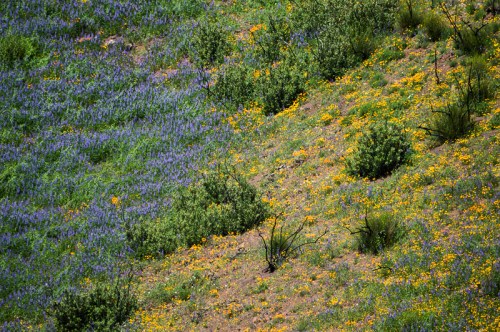
By the 9th day, plants were poking out: grass, vetch, mustard and others. At 6 weeks, shrubs were beginning to resprout at their base. By April, there was skullcap, baccarus, deerweed, and a fire follower called whispering bells (because of the sounds it makes when it is dried up).

Researchers Heath Bartosh and Brian Peterson decided to do a study of this “fleeting abundance” to see what wildflowers would come up three years running after a fire. They set up a series of 1m square research areas across the mountain listing every species and the % of cover. They did this out of curiosity not because someone was paying them.

What they found were 28 opportunists — species like the Mt. Diablo globe lilly — which were are commonly found there, but came on strong because of the extra space and sunlight the fire afforded them. But there were also 17 fire followers like the whispering bells, and golden ear drops. The species that everyone wanted to see, the flame poppy, was elusive at first, but eventually showed itself.

The second year made the work of this research difficult as a native morning glory flourished (they referred to it as trip vine). There was also some nice surprises: Kellog’s climbing snapdragon which hadn’t been seen 80 years, and the sleepy catchfly which hadn’t been seen in 125 years. Bulb plants went crazy: mariposa lilies, fremont star lily. California poppy, Mt Diablo jewel fire were both abundant.

The burnt chaparral was where the diversity seemed richest.

There were other researchers out there as well. Mandi McElroy got a grant for remote cameras and began a study of mammals on the mountain. The cameras have so far caught the obvious ones: black tailed deer, wild pigs, and coyote. But it will take a while longer to sort out the effect on smaller animals. The pigs seem to be doing well from what they have seen so far.

Entomologist Kip Will began a 5 year study of arthropods in the area. Setting out to trap insects on land in the air, day and night, to be as an detailed as possible to get baseline data. So far, beetles are two times as numerous in burned areas, and 16 new species of moth have been recorded on the mountain including the sphinx moth with a whopping 4” wingspan.

Lindsey Hendricks began looking at the effects of the fire on the previously dominant Chamise, looking at growing chamise in different fire affected soils. It turns out the Chamise likes it hot. It only sprouted in soil that was moderately to severely burned soil. In unburned soil the enormous numbers of seeds that chamise produces simply did not germinate.

At the tree level, the oaks came back. Only small handful did not survive the fire. In some cases, the trees were resprouting from the trunk and biggest branches. A lot of big grey pines on the other hand did not make it… Their chemical makeup is such that they burn up quicker and easier than other pines having a chemical similar to gasoline. But they are coming back from seed.

There were few problems with invasives, even in areas where they thought it was more at risk (the bulldozed zones in particular), erosion turned out to not be a problem because the root systems of many plants were still intact holding the soil together (and until this year we had below level rainfall probably did not hurt).

All in all seeing the mountain change from year to year was an amazing opportunity for Hamilton. She had a few suggestions for places to go if you want to check out the burn sites:

  • The North Peak Trail from Devil’s Elbow down to Prospectors Gap. From there, you can either head up to North Peak or down to the park boundary along the Prospectors Gap fire road.
  • Green Ranch Road from Oak Knoll picnic area down to Rhine Canyon and Frog Pond.
  • Perkins Canyon on Ray Morgan Road and Perkins Canyon Trail.

Read Full Post »

A Kingdom at Your Feet

Trent Pearce joined us February 25th, 2016 at the Lake Merritt Rotary Nature Center to introduce us to the Kingdom of Fungi, focusing on mushrooms. As with many of our lectures, I didn’t really know how little I knew.

IMG_2319

First of all, Trent asked what are Fungi? We can say they are not plants… they are in fact closer relatives to humans than plants are. They are consumers of other things, they don’t produce their own food. They also have chitin in their cell walls. Chitin is a sugar that is also found in insect exoskeletons, and is what provides structural support to the organism.

The Fungi kingdom includes yeasts, chytrids (the fungus causing problems for amphibians), molds, lichens, and mushrooms. Fungi split off from animals on the order of 650-900 million years ago. Our common unicellular ancestor has carried on as choanoflagellates (of which there are about 125 species). For a long time Fungi were considered by science as part of the Plant Kingdom. The inventor of our current scientific classification of organisms Carl Linnaeus in ~1735 only had plants and animals separated out as kingdoms. It wasn’t until 1959, when Robert Whitaker separated them out as their own things.

What we know of as mushrooms are only part of the whole organism. They are the fruiting bodies of the larger organization that lies mostly out of site.

The continuous organization is made out of strands called hyphae, which collectively grow into mycelium, which once or twice a year, put up fruiting bodies in order to reproduce.

The fruiting bodies thrust up out of the ground and when they are fully grown release spores from their gills. The spores spread out and mix with the spores from other fruiting bodies. There isn’t just a male female dynamic going on, but something considerably more complicated with some species having up to 20,000 sexual combinations. When the spores meet and match they grow into hyphae and combine, and if all works out, grow into mycelium, and the cycle continues.

The fruiting body grows by being inflated with water pressure, provided by the below ground mycelium network. With the right circumstances you can put a mushroom onto a wet paper towel and have it expand.

These fungus have extracellular digestion. Generally this means that enzymes and acids are excreted from the ends of mycelium, to produce simple sugars, amino acids and fatty acids, but a whole host of bio products gets created which are what makes fungus sometimes a positive thing (thing alcohol from yeast, and antibiotics) but also deadly (thing of all the poisonous mushrooms out there). All of these things are purposed to help protect the fungi in one fashion or another.

There are three general ecological strategies that mushroom fall under: decomposers, parasites, and mutualists.

Decomposers decompose everything from leaf litter to wood. Wood specialists fall into one of 2 types: white rot which digest lignin and leave cellulose, and brown rot which does the opposite eating the cellulose but leaving the lignin. Often these are the mushrooms that look like little shelves on rotting logs, and they sometimes specialize in the wood that they consume.

Other mushrooms are parasites — it might be wood rot fungus that evolved to have a go at live wood. There are both generalist and specialists. Honey mushrooms are generalists, but a type of Ganoderma focuses on Bay Laurel and can often be found at the base of these tress. There are also mushroom parasites that attack insects and turn them into zombies to get the insect into a favorable position for spore dispersal (for example: Ophiocordyceps unilateralis. Some of these mushrooms actually have medicinal uses.

Mutualism is the other broad category of life strategy mushrooms employ. The best example of this is ectomycorrhizal fungi which grow around tree roots. The mushrooms provide nutrients (breaking things down into nutrients) and water to the tree (the mushrooms serve to extend the surface area of the root system). In exchange, the tree provides sugars. Many of these mushrooms have specific hosts… chanterelles live along with hardwoods like oaks. Amonita like pine. The presence of these fungus can have an impact on how well trees germinate.

There are also a couple reproductive strategies that different fungus employ: ascomycetes and basidiomycetes. Ascomycetes is employed by yeast, leaf molds, cup fungus and others. The organism produces strands called asci which are fluid filled and contain the spores. These are pressurized until they explode shooting the spores out (up to 30cm — which may not seem a lot, but these are tiny things). Examples of mushrooms that do this are earth tongue, scarlet cup, elven saddle, and orange peel fungus.

Basidiomycetes grow typically 4 spores on things called Basidia. The spores here are ejected through a process employing water tension… where water collecting on two different surfaces meet, and the release of water tension and the change of center of mass discharges the spores. It’s been estimated that spores are shot off with an acceleration of 10,000g’s! (Money, N.P. 1998. More g’s than the Space Shuttle: ballistospore discharge. Mycologia 90:547-558.)

With a quick guide to anatomy, Trent went on through a bunch of major groups of mushroom, with some first notions of how to identify things. The annulus (ring) is something that covers the gills while the mushroom is coming out of the ground, the remnants of it can sometimes be seen. The stipe the stem, and the volva is an egg like structure that some mushrooms grow out of (mainly Amanita). Any problem with the table below is probably my note taking error, not Trent’s mistake.

Type Cap Gills Annulus Spore Stipe Vulva Notes
Agaricus Dull colored cap Pink brown gills Persistent Dark brown Button/portabella mushrooms amongst others
Amanita Can be colorful White gills Can be persistent or absent Have a Volva Many of these are poisonous
Boletes Dense fleshy Pore layer not gills Absent Variable Grow from soil
Suillus Often slimy Pore layer Annulus present, but often degraded Variable Grow from soil
Cantharellus Atypical trumpet shapes Blunt many forked gills Absent Reduced Grow from the soil, resistent to rot
Russula White cream Attached white gills Yellow Brittle. Flesh breaks cleanly like chalk. Has elongated cellular structre.
Lactarius Has concentric rings Absent White to yellow “Bleed” latex. An oak associate. Brittle.
Hygrophoraceae (Waxy Caps) Orange and Green slimy/waxy cap Absent White Grow in the duff near redwoods and sometimes oak.
Polypores Shelf like growth Pores Absent No stem Parasites and wood rooters. The are hard, made out of the material they consume, and most are perrenial.

The great thing about mycology, Trent offered, is that amateurs are still doing the bulk of the discovery, and that there is still much to know about Mushrooms.

If all this peaks your interest, Trent advises a few things:

  1. Get a book. He gave a few possibilities: Mushrooms Demystified, All that Rain Promises and More, Field Guide to Mushrooms, and later this year Mushrooms of the Redwood Coast (the author is a local amateur mycologist)
  2. Get out and find mushrooms, measure, document, and try and identify
  3. Share your observations (iNaturalist or MushroomObserver.org). There are great online communities who can help.

There are also plenty of local mushroom groups, and online resources like the Santa Cruz Mycoflora Project.

Learning to ID is an important thing especially if you are looking to eat mushrooms. Immigrants are often victims of mushroom poisoning because the mushrooms they grew up with can resemble deadly ones here, but even knowledgable people can make mistakes, and if you are looking for a cautionary tale, KQED has one for you here.

Trent in the winter time can often be found leading mushroom walks in the East Bay hills, and year round leading other fun naturalist events. See more at EBRPD’s event calendar.

Read Full Post »

Our first ever video recorded lecture — thanks to the San Francisco Public Library for hosting us, and providing this. Don’t get used to it though, most of our venues are not so high tech 🙂

Gregory Rosenthal joined us October 19th, 2015 to share his research into the early days of San Francisco. He started out as a scholar of China — but was looking for a place that China and the U.S. connected and landed upon Hawaii.

Kapalakiko — the transliteration of San Francisco in Hawaiian — was one node of a large Hawaiian diaspora in the mid to late 1800s. Hawaiian’s worked all around the Pacific — the large majority as whalers, in the arctic (where they were — perhaps unexpectedly — reliably the best workers), gathering guano, and active as workers and boatmen in California, with large numbers working the gold fields of California (Sutter had 10 Hawaiians in his employ).

This all evidenced by a number of Hawaiian language papers that were in circulation throughout the Pacific — which served as an important source of material for Gregory’s research. 90% percent of Hawaiian’s were literate in Hawaiian, and the papers served to connect the population that spread out over such large distances.

The 1860 census of San Francisco found that Hawaiians were the largest population next to whites. They weren’t just workers though — they were also landowners — although along with Mexicans — many had their land confiscated over time. While they were literate in Hawaiian — the “kanaka” — the term used for Hawaiian workers — weren’t necessarily literate in English and their employers often used this to their advantage (writing contracts in English without fully disclosing their contents).

He’s worked to bring their names back and humanize their story — helping to make San Francisco what it was from the very beginning.

Read Full Post »

Getting Underground

Bruce Rogers, a geologist and cave explorer from since he was a teen, came to us in September of 2015 to talk to us about caves. This was our last talk at the Exploratorium this year. The talk got off to a rocky start with not one but two fire alarms going off! We only had to evacuate once, but we were impressed by how many people (easily 90%) stuck it out.

Bruce starting with a definition of caves as underground, naturally occurring, with some parts in darkness, and humanly accessible. They have fascinated humans since probably long before we were even “human” (if the recent cave findings in South Africa have any bearing). For us they represent beauty, danger, and adventure, where of course for a long time they were likely refuges and homes.

Beyond that, to science and wider human interest they are even more interesting — they are geological repositories, they are workshops of evolution, they are archaeological sites, and holders of cultural treasures.

California has a few different types of caves across its landscape: limestone/marble caves, tafoni wind caves (tafoni is an italian word for small grottos built overlooking the ocean), sea caves, and fissure caves.

The ecology of caves can often be novel and fascinating, with new species often being described when new caves are found. Microbiology provides another level of this — with astrobiologists of late showing great interest in finding how life can live on in places like this, and where we might expect to find things alive on places like Mars.

There are creatures like the California giant salamander, one of the few salamanders to make noise. And of course bats — which Bruce in his cave explorations is careful not to disturb.

One cave near Monterey bay contained a graveyard of skunks, the skeletons of several thousand were found there in 1942. The skunks no longer seem to come back, but there are bats still in the cave. Mountain lions make use of caves in Big Basin.

Of course, all these caves are fragile, and their conservation is always a concern. He showed one example of cave that was discovered in 1954 (through an accident where someone got stuck, it soon became widely known) by 2007 everything had been broken off, the floors sledgehammered, full of garbage, and walls of graffiti. Spelunkers are now pretty wary of telling people of their finds, and recent caves opened to the public go to great lengths to preserve them from the outside. Caves do not renew — or at least not on any timescale we live on.

Sea caves are by far the most common type of cave in the Bay Area, created by the impact of waves along the bases of cliffs. Waves bring a tremendous amount of force to bear on cliffs. During hurricanes it can be enough to bend steel and smash concrete — but even a normal wave brings a lot more pressure to bear than most human activity.

Sea caves can be full of life, fish, seaweed, snails, limpets, anemones, mussels, barnacles, abalone, sea stars, sea lions (seals apparently don’t like caves). They can also be full of sand — the season, tide, and wave action can completely change a cave (he showed one picture of a cave with people standing upright in, and the next was someone crawling through the sand).

If you have an inclination to visit one — be wary! Be careful about the tide, and only go at extremely low tides.

There may be things to discover as well — At least there was… in 1927, a couple recovered some stolen silver in one of the sea caves. A stash of stolen goods from Hotels through San Francisco.

The Farallones also have some caves, quite large ones, with endemic species of a cave cricket and a salamander, and some very uncommon stalactites, and beautiful flowstone.

The only fissure cave he talked about is now on private land. There are not many limestone caves in the region either. The other most common cave type you will find in the Bay Area are tafoni caves — Castle Rock State Park have good examples, as well as Mt Diablo, and the Vasco Caves. The Vasco caves are part of a closed preserve: they have some 2000-4000 year old cave paintings and rare wildlife and plant species. You can get naturalist led tours of it in Spring and Fall.

If you want to know more about caves, preserving and exploring them, Bruce pointed us towards http://caves.org/

Read Full Post »

Brenda Goeden of BCDC and Ian Wren SF Bay Keepers joined us on August 19th, 2015 at the Exploratorium to to talk about what gets dredged out of the San Francisco Bay.

Most of the dredging that goes on in the bay is for navigation. This is mostly through mud — 80% of the Bay is fine grain mud, and it is dug out to allow deep draft vessels to come through, and keep waters by marina’s clear. The dredging aka mining of sand is mainly for the construction industry – it becomes cement, asphalt, road-base, sub-base and general fill. The grains of sand are grains (.002 to .08 inches in diameter) bigger than mud, and smaller than gravel. it gets mined on demand, not necessarily day in, day out.

There are two main areas whether the sand comes from: Suisun Bay and the Central Bay. Suisun Bay is a finer grain of sand which is often used for back fill in trenches. The coarser sand of the the Central Bay is used for cement. Sand is only found in the high flow areas of the Bay where the water has enough energy to carry the sand. Mud is taken out to the slow wide sides of the Bay.

Sand Flow in the Bay - Barnard et al. 2013

Sand is important for a number of reasons outside of its commercial uses — it helps build marshes and beach. It provides shoreline protection as it takes more energy to move, it provides a particular kind of habitat, and on the shore provides a place for recreation and having a place for viewing wildlife.

The amount of historical sand, and sand in the Bay is difficult to measure. Most of the sand in the Bay comes from the Delta and the larger watershed (40% of California’s watershed drains into the Bay), and estimated 1.2million cubic yards, with another 300+ thousand cubic yards coming from local streams. Where not blocked, the rivers and creeks, slide and bounce the sand along into the Bay.  Storms and other high flow events are key in moving the sand along and into the Bay and beyond.

The sand also is carried out into the ocean, and large dune field lays under water past the Golden Gate Bridge. This was once a wide delta of sand, but has been slowly growing smaller. This changing shape of this sand has affected how sand flows both inside and outside the Bay. The pattern of sand dispersal on Ocean Beach has meant the northern end of the beach has been gaining sand, and the southern has been losing sand leading to fast erosion of the shore. The bay itself is also losing some protection from ocean waves in this process as well. Crissy field on the other hand has benefited, gaining sand from both flows headed out to sea, and sand coming in along the shore.

There’s not a lot known about the habitat underwater in these sands. The Central Bay sand area is the deepest in the Bay 90′-300′ deep where the water is salty, deep, cold, and fast. Aka difficult to study (there has been some studies monitoring what is brought up by the sand miners). We know there are wondrous things going on down there, like the migration of Dungeness crabs — marching in to lay eggs, and then marching out again — but no one has ever seen it or knows the pathways.

Suisun Bay is shallower, warmer, and less salty. The two areas are pretty different, but in both cases these are deserts compared to the meadows of mud. The organisms living there tend to be smaller, efficient, and highly adapted.

Humans have had a huge impact on these fields of sand — the biggest being the pulse of sand brought down from the Sierra’s by gold miners, and estimated 10x the usual flow of sand. Before that, and before many of the rivers and streams were dammed. The flow might have been around 2 million cubic yards. The sand from mining continued to pulse through the system and is only recently pretty much all gone. Now a large portion of the pool of possible erodible materials is trapped behind dams and the delta tunnels.

We still have sand, and we still have sand coming in, but the question now is how much sand do we have, and how much can we afford to take out. Mining has been happening since the 30s, peaking in the years 1949-79. Much of the sand is used locally shipped to different dispersal points around the Bay.

Dredge mud goes to different places, a lot gets shipped and dumped out at sea, or dumped at certain disposal sites in the Bay itself (inside the bay this can disperse contaminants, cause turbidity). These are not the preferable options — that favored option (by BCDC) is helping restoration efforts, filling land that has sunk below sea level on the other side of levees. This is the unfortunately the most expensive option, which there are not a lot of funds for, and small marinas don’t tend to have funds to support that kind of work, and dredging for ports is an expensive enough business that any additional fees would likely be too onerous.

San Francisco Bay Keeper is involved in the issue, hoping to bring in the perspective of the overall health of the Bay and nearby waters, and the sand being an important part of it. The sand taken is not replenished, there is a net loss, and they want to make sure we keep relic sites, and keep mining more in active parts of the flow. They are also looking to insure there is proper compliance and that companies don’t end up taking more than they should. They are looking through commenting on proposals and active litigation to reduce the amount of sand mining going on — to being sand mining to a sustainable level.

On the flip side, if local industries turned to external sources for sand, there may be equally damaging impacts — leaving aside where the sand is being mined from, the carbon costs of shipping that sand by barge or truck would not be small.

The biggest question we seemed all left with was the complicated nature of the question. A unknown or at least unseen, but super valuable resource here in the Bay below us. How much is there? and how much can we afford to take out?

Read Full Post »

Joel speaking at the Exploratorium

Joel spoke at the Exploratorium on July 15th, 2015 exploring in conversation and images “Seep City” – a catalog of water discoveries in the city of San Francisco.

Joel’s map of Seep City shows today’s landforms, but overlays the springs, water, and waterways of the past (I like how the map is a lacking in any streets — makes it funner to try and identify the places you know). Crissy field used to be much larger (the current marsh is a “sculpture of a marsh”), and there were large marshes on the eastern side of the city, a tidal waterway running up to the Mission District, and Islais creek wending it’s way into the peninsula. The sands also held many temporary lakes and water ways that would come and go with storms (and the shifting sands). They are barriers and dams, but could be blown away in a storm. Creeks flowing out of the dunes were often temporary or seasonal.

San Francisco — unlike a lot of cities — is not built on a river, and a question you might ask is why we have these seeps and springs at all. If you stripped all our human construction and put back features we’ve flattened or otherwise shaped, you’d find a lot of sand, as well as some serpentite and chert. Before all of our hardscape, rainwater would have been absorbed by sand and passed underneath it, but there is also water coming out of the tops of hills despite the drought. Joel still has yet to answer the question where this exactly comes from.

There were someplaces the water always flowed. The Ohlone, not a stone age people, but perhaps better described as people of the fabric age, made use of water based technology and had daily rituals washing in the creeks here. But there were only a few hundred there when the Spanish arrived.

The Spanish built their settlements in San Francisco around a couple of springs, in the Presidio and in the Mission. Captain Anza noted the spring that flowed out of the dunes near where the Mission was to be built was enough for a larger water wheel.

As the city developed, San Francisco used local water for laundries and for bottling, water was brought around the city through flumes built by private companies selling water to the more settled regions of the city. Lobos creek was one of the sources the flume running along the coast. Another had a water works that created stow lake. Safeway in the Mission/Castro area used to be a reservoir with water pumped over the hills from outside of San Francisco. Tank hill had a tank of water.

Water was also stored around the city for fighting the frequent fires of San Francisco’s early days. You may see the circle and square bricks circling intersections of San Francisco Streets. These continue to hold water for fighting fire.

Most of our water no comes from outside of San Francisco. The Presidio gets 80% of its water from its own springs. And lot of that water still flows, just mostly out of sight, channelized and covered over. There are of course many more water features now in the way of fountains and reservoirs, and some of that come from local water. The fountain in UN plaza (7 piles of stone representing the 7 continents apparently) actually runs on ground water that people refered to as Hayes Creek. BART has to pump water of its tunnels continually. Water runs under the Armory building in the Mission. There is a brewery at Haight and Steiner which hope to use the water underneath their store. The presidio has a creek you can shut it off in 3 places in case someone falls in.

This map is of course just a start, there are seeps and springs all over the city, and while this map holds many — Joel continues to hear of new possible springs and seeps. Keep up to date with this project at his website: seepcity.org

Read Full Post »

Lauren Rust spoke with us on June 30th at Green Apple Books. She came to talk to us about her work at the Marine Mammal Center, the research they do, and the animals they attempt (and don’t attempt) to rescue.

The Center covers 600 miles of California Coast from Mendocino down to around San Luis Obispo. They care for around 500 animals/year. They might stay up to six months, but usually an animal’s stay is a few weeks to 3 months. 50% are released and 50% end up dying or being euthanized, a few end up in zoos (healthy animals that otherwise can’t be released, for instance if they were blind). They have a big pool for cetacean’s like dolphin’s but usually they serve as triage pass them on to others for longer care.

Their most common animals are California Sea Lions, Harbor Seals, and Elephant Seals. Guadalupe and Northern Fur Seals, and Stellar Sea Lions are less common to the Center.

The number of animals they have taken care of over the years has grown since their start in 1975. Their peak year thus far was in 2009 when their new facility coincided with an outbreak. 2015 is close to those numbers and will likely surpass it.

The reason for that is the large numbers of starving young sea lions washing up on California shores. The reason for this influx is water temperature — a patch of warm water known as “the blob” that has been bobbing off the coast of California since 2013 and is now hugging it. The effect of that water has been to inhibit upwelling, which means less phytoplankton, which means less zooplankton, which means less fish, which means… problems for sea lions.

California Sea Lions have taken the biggest hit because of a number of reasons. Although they range the whole western coast of the U.S. down along Mexico, they give birth in only a limited number of rookeries the furthest north being the Channel Islands.

77% of breeding females give birth each year to a pup (they are polygnous with one male to many females) and gestate for 9 months. The mother spends the first few days ashore with their ~7kg babies but then start to make foraging trips, finding their pups by vocalization when they return to shore. The mother nurses them for 6-11 months. It’s not easy being a seal mom!

What happens with this is that the warm water, having kept the fish away, keeps the mother further and further away from her pups. Eventually the pups take to the water, seeking food, and then wash up malnourished onto mainland shores (the vast bulk unsuprisingly were in Santa Barbara). This started happening in Dec of this year — in a normal year a pup would have been nursed through May. Researchers on the Channel islands have seen lower birth rates and mothers having a harder time catching food.

600 pups have been admitted, given fish milkshakes as well as subcutaneous fluids with suppliments and anti-parasites (sea lions typically have parasites they have picked up from fish, so they try not to treat them too much). Eventually they are worked up to food, and one of their conditions of release is that they eat free food.

One lesson learned this year given the numbers of malnourished patients, not giving the pups too much — spaing it out or just giving less. It sometimes takes the pups a while to figure out what to do with fish. They’ll drag a fish on a line to simulate swimming (most the of the fish is frozen), or sometimes drop a live fish in to simulate.

Once they’ve gained weight, have clean bloodwork, and eat alongside others, they get a flipper tag and are released (sea lion pups are usually taken south, seals are relased near chimney rock on Point Reyes — never on a public beach — and elephant seals where there are rookeries).

Elephant Seals and Harbor Seals tend to be much younger patients, from premies to a few days old, and require a bit more attention and time at fish school (the california sea lions often have some experience with fish in the wild).

Other reasons for the mass strandings this year have been considered, radiation, ocean health, contaminants, and other human interactions, but other marine mammal species have not been equally affected and the big problem has been with pups. Elephant Seals and Harbor Seals have different life cycles, both with much shorter periods to nurse.

Malnutrition is what brings most patients into the Center, the next leading cause of strandings is Domic Acid Toxicity. This is cause by the algae of red tides, which is eaten by fish, and then by sea lions. Its effects in sea lions are memory loss, brain damage, reproductive failure, and seizures similar to epilepsy. Sea lions will shake, and wave their heads and flippers, eyes shaking. They can be confused and aggressive in this situation.

These animals are treate with anit-seizure medications for about 10 days. Cronic cases with brain damage are euthanized.

Lauren’s main job is not care but research, so she spends a lot of time to necropsies. This research supports over 40 projects from different scientists each with their own set of criteria: age, sex, death, time of death. They might send on eyes, kidneys, lymph nodes, cells, skin for genetics, teeth for knowing age (teeth have rings — something they are validating against known tagged animas), or parasites to one researcher or another. Skeletons go to the California Academy of Sciences.

One of things the Center has been studying is one of the leading causes of death in adults… carcinoma. 18% of the adults admitted die from this, mostly females. Since 1998 they’ve putting together samples of dead females with cancer, and females without, with a goal of 300 each (they are at 130), with a goal of learning more. Herpes virus seems to be a corallary, but they are hoping to have a better understanding of its causes.

They do also do research on live animals — but only opportunistically — by taking samples in the course of routine care, getting a little bit of extra blood, urine, and hair for things like mercury samples, and doing nasal and rectal swabs. All released animals get a tag, and they occassionally place satellite tags but these are expensive.

One goal of the research is to have create the MMHMAP: marine mammal health monitoring and analysis. Mappng causes of death in marine mammals and cetaceans and correlating that with ocean health (like temperature and the like).

Another bit of research they participate in is whale strandings. This is the California Academy of Science’s bailiwick, but with large whales they often need all hands on deck to help do necropsies. About 25 or so strand per year with around 5 being larger whales. This year has seen a slight uptick (a couple of humpbacks, a grey, one entangled killer whale, and a rare sperm whale in pacifica, one of two whales there this year), but there seems to be no common thread other than there being more animals offshore.

The necropsies look for cause of death: broken bones, hemmoragging in the muscle. Age can sometimes be gleaned from the wax in the earbone, but it is not always accessible or easy to read. Most deaths are either some sort of traume or disease, but larger number are unknown. The good news is that this research has already informed boat operation — reduced vessel speed and changed vessel lanes.

And that’s the goal of all this research — to make things better for marine mammals. The Center’s particular research comes back to treat future patients, so even patients who don’t make it play a part.

You can learn more about the Marine Mammal Center’s work, or even help take care of them (a lot of the work is done by the hands of volunteers) visiting http://www.marinemammalcenter.org

Read Full Post »

Kieth Hansen joined us April 29th, 2015 at Green Apple Books. The first of our series’ “wandering era.”

Kieth Hansen has been hooked on birds since he was a kid, when his brother ran into to grab him, and showed him a Cedar Waxwing in the woods of Maryland. Not long after, his family moved to Fresno, where the Sierra Nevada became his backyard, and he went deep into birding, and on to do a 3 week stint on the Farallones with PRBO in 1974 as the youngest person to be allowed on the islands. Since then his birding has taken him all over the world.

He also came from an artistic family, and those two interests were have been tied together since his senior year of high school. His first book was a coloring book about birds of the Sierra, followed by a 4 year project to produce illustrations for “Discovering Sierra Birds” co-authored by my Ted Beedy and Steve Granholm.

His most recent project has been one 14 years in the making — 1400 paintings of 320 species each with their different plumages based on sex, age, seasonality — called “Birds of the Sierra Nevada: Their Natural History, Status and Distribution” with co-authors Ted Beedy and Ed Pandolfino.”

Originally it was planned as one book, but the field guide + life history became too much. The life history book has been published first with example images from the field guide illustrations.

To paint one illustration takes about 2 months from a blank canvas, a slow process of building up the picture of the bird, starting with pencil, measuring out and couting the feathers; wetting the bird and starting with a neutral tint for shadow, then adding color, sheer washes over each other, drawing more while the paint drys, then back to paint; paying attention to the translucency of feathers as they overlap; the full colored bird building up slowly but surely; the final touches in place with colored pencil.

A lot of these images are made up, not directly from a photo or illustration, but trying to get the bird in the perfect pose: pulling from his own years of observation, videos he has taken, specimens, other books, and photos. Consulting with his many birding friends and experts in the birding world to make sure he has gotten it right. This is his 13th book, and for the most part he can block birds out without too much work, it’s the details that take the time and effort. Although he enjoys it, he does not draw as much as he would like in the field.

His love of birds is clear from the beauty of his final exquisite images, and he takes inspiration from his trips out in the field (he showed a great video of birds in the Sierra’s) and also in his backyard in Bolinas. His studio has proved itself an excellent little observatory as well.

His images are fairly small — but this is mostly a factor that he has had to draw so many, and that they will actually be even smaller in the book. He has been pleased to see how well they can be blown up though. One of the most important factors in getting the birds right is their weight and center of gravity — how they carry themselves, and their relation of their legs to the body.

We still illustrate bird guides he says, because they can be drawn in a neutral space, the same generic conditions and lighting to make them easier to compare, and it is easier to highlight and show features. A photo guide has the disadvantage of having a background and the varied lighting, and varied conditions. With an illustration it is easier to show the details and variations that matter.

I hope that he keeps illustrating birds for many years to come. His studio in downtown Bolinas is well worth a visit (he related a funny story about why he has so many hummingbird feeders). He also leads tours through a company called Sacred Monkey. More information can be found on his website at http://keithhansen.com/

Read Full Post »

Joel Pomerantz (my partner in this lecture business) talked to us on March 19th, 2015 about his research into the flood of 1862. At first he did not find a whole lot, until he stumbled across the term “freshet”. That opened up a whole new line of research — which led to this wonderful and somewhat unconventional lecture — a “choose your own lecture” adventure: offering a list of topics on which he could speak.

Lithograph with frame K Street A Rosenfeld, SF

He did give some background to start. The term “atmospheric river” is a relatively new one. I hadn’t heard of it myself until I heard a lecture on drought last fall, but it popped up in the news a lot at the start of our winter storm cycle (the threat of which caused more chaos than the actual event this year). These rivers in the sky are actually the delivery mechanism for a lot of moisture from the the equator to landmasses. The moisture isn’t necessarily even visible from space only recently have microwave satellites been able to track them.

One of these rivers pushes up toward the northwest, and under certain circumstances, storms in Alaska (the results of other atmospheric rivers) push these rivers further south into California. The total water in these systems can be huge (10 to 20 Mississippi’s worth), and what fell in California in 1862 was exacerbated by a drought in the prior year, and a hard freeze that followed. What measurements we had: San Francisco saw 24”-37” of rain in January alone (19-20 is the average for the year). In gold country there was 108” in a month.

All this wrought terrible destruction, pretty much every mill, ferry, and bridge were washed out (many many deaths happened with people trying to cross rivers), tens of thousands of dead cattle washed up on beaches, low lying farms inundated, Sacramento flooded.

Newspaper accounts of the time (akin to the blogs of today) had all sorts of accounts of how terrible it was. Every day people thought it could not get worse, and each day it did. A Southern Californian woman recounted how in a 6 week stretch there was not time to dry even a handkerchief.

Given the prior year’s drought, sediment got picked up from the ground rather than the water being absorbed — and given also the blasting going on for mining, a tremendous amount of soil and rock was moved and polished by the high fast moving water.  Water covered 30’ high telegraph poles in some places and steamships were able to go anywhere.

The freeze that followed didn’t stop it. The freeze was a deep one down to sea level, but it didn’t stop the water from moving and ice tsunamis formed — ice piling upon ice, pushing up onto land crushing whatever might be in its path.

San Francisco Bay clocked no flood tides for over a week, raised as it was by 7’, and the water was fresh enough that steam ships didn’t have to trek to their usual freshwater streams to get water.

The effects did not happen all in one go either. Drought followed in 1863 and 600k more cattle died, pretty much the last of the stock that came from the original Spanish settlements. Michael Barber of UC Davis thinks that this is when native grasslands were supplanted, when new cattle was brought in directly from the east. Tree squirrels may have also taken their place at this time — so many ground squirrels were killed into the floods.

The greatest source of information about the floods comes from Sacramento. Governor Leland Stanford was inaugurated on Jan 10th, 1862 and was said to have had to row to the ceremony. Business had to be carried out on the 2nd floor of Sacramento, and 1000s of miners came down from the hills looking for a way back to San Francisco. A fair number of people turned their backs on California altogether.

The story quickly made its way into stories and song: Bret Harte’s Luck of Roaring Camp (the story was very successful, the author himself helped rescue people during the floods), a musician Max Zorer who named his songs after the flood (The California Flood Mazurka Dance), and a minstrel song published in 1863 called Down By the River Lived a Maiden, by H. S. Thompson, about a woman who drowns while chasing her ducks away from the river, which later was the inspiration for a song you are all familiar with Oh My Darlin’ Clementine. Joel gave a fabulous rendition of the original — an “old timey” sounding tune, with its amusing but ultimately sad lyrics (sadly my recording of this event failed entirely).

Down by the river lived a maiden

Joel had us speculate on why this disaster faded into the background, beyond the terminology, until recently there was little to be found on the subject. There is some level of time passing — we would not expect much of a history of Hurricane Sandy in 150 years perhaps, except that we are now building on the places that were designed as flood plains in the 1850s. His hypothesis is that it might be the flood control administrators who did not want to talk about it — the storm was of such a magnitude that it is unlikely we could build to it. It’s only recently that people have begun to think about a response (on such effort referred to as the Ark Storm). 16 million people live in areas which were underwater in 1862.

How long ‘til the next one? It is really impossible to say. There have been 2-5 storms of this magnitude in the last 2000 years (measuring from sediment layers taken from lakes). Ultimately, it is up to us citizens to remember, research, pass on, and act on this kind of knowledge.

At the end of the lecture, I am sure that Joel could have gone on much longer. Keep an eye on http://thinkwalks.org for updates and future talks on his flood research.

Read Full Post »

John Wick came to us on February 19th, 2015 to talk to us about soil. It turns out that our millenias of farming & ranching have left us, overall, with some pretty wretched soil. Soil that is also conspicuously devoid of carbon.
Source: Intergovernmental Panel on Climate Change (IPCC)

Source: Intergovernmental Panel on Climate Change (IPCC)

John’s route to having a potential fix for capturing carbon back from the atmosphere started in a deceptively simple desire to turn his land back to nature, to re-wild a bit of California. They had 540 acres, three valleys of land. It was not so easy as he had imagined — left to its own devices, the ecosystem fell into chaos and a riot of invasive plants took over.
They turned to Dr. John Creque, an scientist and expert in land management, who suggested a controlled application of cattle might help nudge their system back towards native systems. And nudge it did, by 2007 their rented cattle, brought in in April when the swallows came and moved 67 times through 5 weeks, had results. Native perennials began to show up, meadowlarks showed up in great numbers, eagles arrived, and the quail population exploded.
Over time, they became interested in whether this was possibly sequestering C02. They turned to another scientist, Dr. Silver who was skeptical, who didn’t think it was likely, and who didn’t think it would be possible to measure, but she was wanted to do the research.
Grassland it turns out are big carbon stores, and rangeland now covers more of the earth than forests, so it had potential – if this proved out, there was a lot of possibility to sequester a lot of carbon. And do the Marin Carbon Project was started. They took samples before they began trying to get an idea of what carbon was already there, and then they began with a series of experimental plots both on his land and in the Sierra Nevada.
One aspect of this was grazing, another aspect was putting compost down… half an inch. And they began taking weekly readings. And the results were amazing — 30-70% increase in forage compared to control, more water retention in the solid, and an additional ton of carbon per hectare sequestered. Even more interesting was that no additional compost needed to be added (and 96% of the carbon ended up stored), each year and additional ton/hectare was stored, and perennial grasses dominated — and that result happened in both areas.
The same experiment was then duplicated on other farms and dairies, with different grazing practices. There still had to be good grazing management, and there had to be compost. Manure and other fertilizers do not work as well, fertilizer is the big can of coke of agriculture, lots of empty calories that don’t do a lot for the system as a whole.
And the most important thing in all of this is the soil, and how the plants interact with it… the plants take in CO2 produce oxygen and, but they also exude sugars — carbon, which get taken up by the microbes in the soil… and this is where the magic of carbon sequestration happens.
The two big questions are cost and scale. Additional testing showed that only a quarter inch of compost is really required. Some of the cost is covered by selling carbon credits, and tests are being designed to take it to scale, including a million acre project on BLM land. None of this depends on new technology, just good practices that have been developed with silence.
The increased water retention is also a big draw to Western farmers and ranchers who are now deep in drought. But the most important news for our long term future, is that even including the full life-cycle of Carbon costs to this project (transporting cattle, and compost, creating compost, and burping cows), the potential level of carbon sequestration is astounding.
They’ve worked out a strong protocol that requires good grazing practices, and not allowing the disturbance on intact systems, no increase in stocking, and no noxious weeds.
The project’s focus on rangelands is based on the fact that there are so many, and that with enough land devoted to this practice C02 in the atmosphere could be brought under the 350 mark. So much land has been leached of its carbon by bad grazing practices, 60-70% of solid C02 lost over the last 10,000 years, there is a lot we could do to recover that.
They are working on many ways to provide the compost required, composted manure, and chicken manure (compost piles that are hot enough destroy pathogens and deactivate other dangerous chemicals), and the potential to use human waste as compost (using something like Gary Anderson’s fiber chips).
The only challenges are perhaps convincing people to use it, and on that front their seems to be great interest from governments around the world (they recently hosted a big delegation from China) and it is the UN Year of Soil.
It seems incredible, but this management of soil, this management of the microbes within our soil, could go a long way to bringing our carbon back under the line, and with renewables and efficiency, could do way better.
To find out more details about the project and their original science (any incorrect details above are due to my poor note taking abilities), visit the http://marincarbonproject.org

Read Full Post »

Older Posts »