Feeds:
Posts
Comments

Streams to Sewers – SF’s Natural and Un-natural Drainage
Guest Speaker: Greg Braswell
7:30pm, Thursday, May 15th, 2014
FREE at the Randall Museum, 199 Museum Way, San Francisco, CA 

How did the old Precita Creek become the complex sewer crossing which now goes under Highway 101? When, where and why did Mission Creek go into the sewer? What are the ramifications of our sewer history and the ancient creeks they sometimes follow for today’s urban outflow systems? Greg Braswell will lead a pictorial exploration and discussion of his research on the muck and brick of San Francisco’s sewer history.

Water coming in from land on ocean beach

Most of us know Yerba Buena Island (aka YBI), if we know it at all, is from tunnel we drive through to get from one end of the Bay Bridge to the other. We may have even gone to Treasure Island, but Yerba Buena is a bit of a forbidding mystery — it’s current owners do not encourage visitors. Ruth Gravanis joined us April 17th, 2014 to uncover some of that mystery.

Two thirds of the island is still mostly owned by the Navy — although not for long, the intent is for them to hand the island over to the city. The other third is owned by the Coast Guard whose station will remain after the Navy is done for good.  Soon this island, will be a proper part of the city, and connected to the easy bay by a pedestrian & bike bridge, with new development slated for both it and treasure island. There is much to know and discover about this place.

~10,000 years ago, it wasn’t an island at all, but a hill in the broad valley that was soon to be the bay. The story of who lived there before the Spanish is still uncertain, but the Island seems to have been used by two different people’s of differing statures and burial practices. The island was used as a fishing camp and a place for gathering acorns. An extensive archeological survey was done, but details have been kept private.

The first westerner to name the island was Juan de Ayala in 1775, who called it La Isla de los Alcatraces (Island of the Pelicans — there is some controversy as to whether he called it this, or the map was transcribed correctly). For whatever reason, it was an English Captain, Frederick Beechy, who called named Alcatraz Alcatraz. He named Yerba Buena after the herb that grew all over the island at the time (the plant no longer grows there naturally).

The name didn’t entirely stick, it has been referred to as Sea Bird Island, Wood Island, and Goat Island. When the island became an official part of San Francisco in 1850, Goat Island was the official name. Goats had been exiled to island after they wrought havoc on the mainland. It was the petition by the Native Daughters of the the Golden West that brought the name Yerba Buena back to the island.

The Island was quarried in the 1860s and the stone was used extensively in Oakland and San Francisco buildings. The Army had a base on the island in the 1860s-1880s as well, but nothing remains on the island of this period. However, two buildings were moved to Angel Island. A lighthouse was built in 1875. Many of the trees seen on the island today are a result of an Arbor Day in 1887 where schoolchildren were brought by ferry to plant trees… a project of Sutro, General Vallejo, and Joachin Miller.

The Army handed over their base to the Navy in 1898 and officers mansions began to be built. Admiral Nimtz was the one of the last Naval officers in residents.  Aside from the mansions, the bridge, and treasure island, all sorts of things got built: administrative buildings, a 1 room schoolhouse, a mine factory, a tower for tracking ship movements.1973 the Coast Guard took up their third of the island. The Navy ceased operations on the island in 1997.

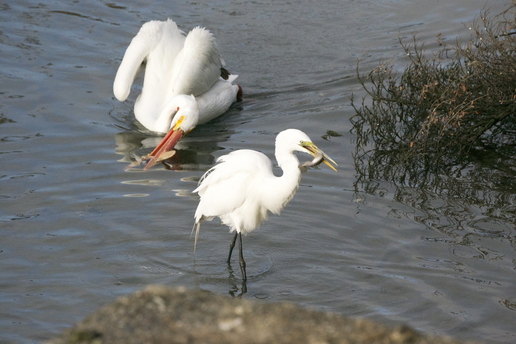
But the cultural/historical side of the island is no the only thing — it has a rich natural history as well. A rare plant study commissioned by the Navy found significant remnants of the original habitats, oak woodlands, dune habitat, tide pools, riparian scrub. A rich mix of native plants, insects, fungus, marine mammals, and birds.

There are many threats to these pockets, invasives like ice plant, eucalyptus (thanks to the Arbor Day in 1887). Eucalyptus isn’t completely without merit, it does provide roosting sites for falcons, and potential for bats, but they need light and space around them to let other things in (here in the Bay Area, not in Australia, very little grows under eucalyptus except invasive ivies).

The next question of course, is when the bike path comes in, and when the Navy has handed over the Island, what comes next. It is likely to become more of a recreation destination, more people will be living on it, and on treasure island, and we have to make sure we do not love it to death. A habitat and sustainability plan is already part of the development agreement, but there are still many things that have yet to be decided — how and where the bike path comes in being a big one.

You can follow the ongoing project at http://sftreasureisland.org

To learn more about the natural side of the island, check out this video from ShengChun Li, and the Treasure Island Museum
http://vimeo.com/91248560


David Liittschwager’s idea of one cubic foot partly started with the idea of having a manageable sample size (the talk was given March 20th, 2014). It is not an uncommon practice to find a limit around observations. So looking at a one cubic foot volume for visible species collecting at different times to find representatives of one day’s time. The size also reflects a common collecting practice of using 5 gallon buckets for collecting, and it is a similar volume.

But in has not turned out to be very limiting. The “dirty secret” for David is that he’s never really finished cataloging within those limitations. The biodiversity that can be found is amazing if we take the time to look. Even a pile of leaf litter in new york city turned up 100 species.

The spots to which he went were chosen by the likes of E.O. Wilson for the biodiversity they know is present. And the most spectacular of these locations have been tropical reefs. He flipped through amazing photo after photo of creatures collected from this little space and carefully sorted out to be identified and photographed.

All those creatures aren’t there all the time of course, but things move and water flows over the reef and through the open skeleton of one cubic foot. Collecting at different times of day and night then going through the process of sorting and identifying and photographing. It took about a month to come up with a representative sample of 24 hours. 

David looked up with some chagrin at a leafy acquatic plant, and said they should have spent time looking through the leaves, they would have found a ton more.

More recently he was out just at the mouth of the San Francisco Bay 100 yards west of the GGB, 100 yards south of the north tower, seeing what pass through a cubic foot of water as the tide moved in out, pulling in with a 300 micron net: mites, water fleas, tons of cephalopods, algae, crab and fish larvae, skeleton shrimp. With an 80 micron net they pulled in the glistening forms of diatoms. On a back of the napkin calculation, in a normal 24 hour period of spring tide, nearly a quarter million linear feet of water would pass through that cube — and maybe  2.6 billion creatures would flow through that space. 

David’s work in these small spaces shows us a different magnitude of beauty and grandeur, life, diversity, and abundance at scale we would not expect. Another lesson in all that we do not know about the planet we inhabit.

Find out more about David Liittschwager’s work at liittschwager.com.

Image

It’s not actually a lake! All the squirrels are imports! And yes, there are sharks that patrol the waters of this beloved urban slough.

We’ll go on a whirlwind tour of all five Linnaean kingdoms and learn how some of the animals, plants, fungi, protists, and monera fit together in this misnamed watery ecosystem.

Though you’ve walked around its three mile circumference many times, there’s so much more to learn about the process and results of renewed human research at Lake Merritt. Check out recent bio-blitz compilations and other citizen and scientist cooperative research.

Presented by environmental educator Constance Taylor, founder of Wild Oakland.

The Natural and Cultural Legacy of Yerba Buena Island
Guest Speaker: Ruth Gravanis
7:30pm, Thursday, Apr 17th, 2014
FREE at the Randall Museum, 199 Museum Way, San Francisco, CA 

To thousands of Bay Area residents, Yerba Buena Island means nothing more than the tunnel that connects the two spans of the Bay Bridge. But this little island is one of the Bay Area’s hidden treasures – a fascinating place with remarkable remnants of indigenous vegetation, resident and migratory wildlife, astounding views, and a complex cultural history.

Located only a mile and a half offshore of SF’s mainland, YBI is one of the Bay Area’s least known ecological secrets. Here we can find biological communities that include oak woodlands, riparian and coastal scrub, grasslands, and sandy beach. These habitats support a rich diversity of birds, butterflies and other wildlife.

The island’s human history begins with the First People, who used the island as a fishing camp and burial ground. Ownership, or claimed ownership, of this island-with-many-names passed from a multitude of private parties under Spanish and Mexican rule to the United States – at various times held by the Army, Navy and Coast Guard. The extant “torpedo factory,” lighthouse, and officers’ quarters on the National Register of Historic Places help keep the memories alive.

The speaker is Ruth Gravanis, long-time YBI watcher.

Zara McDonald, President of the Felidae Fund, came to speak with us on February 20th, 2014.

Launched in 2006, the Felidae Conservation Fund does critical field research and conservation with cutting edge technology, innovative K-12 programs, and community involvement. There are 36 felid species, and all are in decline. These species are a powerful indicator species as they are apex on the food chain. They are being killed or dying  by habitat fragmentation, road kill, rodenticide poisoning, loss of genetic diversity, loss of native prey, illegal hunting and trade. Felidae’s education and outreach programs are designed to increase understanding and awareness and thus enable the conservation of  entire ecosystems. The Bay Area Felidae group is BAPP.

There are 40 common names for the Puma/mountain lion. The historic range was from the Yukon to the tip of South America, from sea level to at least 17,000 feet. In 1970 less than 600 pumas were in California. By 1990 the population was 117.

Females weigh up to 150 lbs., males up to 260 lbs. Measuring head to tip of the tail, the tail makes up 40% of the cats length. An adult males needs about 6000 calories a day. A female gives birth after about 90 days and can reproduce when there are 2 years old. Their litter is from 2-4 and the kittens are densely spotted. These spots fade as they grow up. Females need a territory of about 50 square miles, males from 100-400 square miles. They live solitary lives. Life span is 6-13 years.

There are a number of factors that continue to whittle at the number of pumas in the state.

One is depredation, and according to state law, if a puma attacks a pet or livestock in California, the owner can acquire a depredation permit to have the puma killed. In recent years, the number of permits issued has increased to about 100 per year. This number is higher than the sport hunting quotas in the states that allow puma hunting.

In order to help reduce this number, one of BAPP’s goals is to provide better education for pet and livestock owners living at the interface between the developed and natural worlds. Something as simple as keeping pets in at night, or using proper fencing or guard dogs for livestock, can reduce or eliminate incidents such as these, which protects both human-owned and wild animals, reduces community tensions, and minimizes the conflict between humans and the natural world. Rare incidences, 3/year in CA, of pumas being killed when wandering into developed areas are generally orphaned young males who’s mothers were killed and the young male was never taught to avoid humans for their survival.

Another is road kill which leads to the deaths of about 60/year in California. California’s habitats continues to be fragmented by ever increasing number of roads. When pumas cross roads to reach the habitat on the other side, there is significant danger that they will be hit by a car. Given their size this is not only dangerous for the puma but also for the human occupants of the vehicle.

To address this issue, the BAPP team is evaluating puma tracking data from the field research to locate frequent crossing points, especially on Highway 17 which is an especially dangerous road for pumas. Caltrans is now taking a pro-active approach to retrofitting roads with wildlife underpasses, and they have requested the data from the project as it becomes available to help guide their road development activities.

According to the California Department of Fish and Game, almost nine out of every ten reported puma sightings are not actually pumas. They are dogs, coyotes, bobcats, raccoons, deer…. even large house cats.

Though the increase in human-puma conflict is real and needs to be addressed, it’s important to keep in perspective that rather than challenging humans over the loss of their territory, pumas are quietly adapting to the encroachment and destruction of their habitat by adjusting their patterns, and are successfully avoiding conflicts with humans far more than we realize.

For more information and to help please visit Felidaefund.org and bapp.org.

(Thanks to Phillip Gerrie for this month’s notes!)

Minature Marvels – Portraits in Biodiversity
Guest Speaker: David Liittschwager
7:30pm, Thursday, Mar 20th, 2014
FREE at the Randall Museum, 199 Museum Way, San Francisco, CA 

A Male Pacific Oyster, Crassostrea gigas Whisky Creek Shellfish Hatchery Netarts, Oregon

Photographer, David Littschwager, will share some of his amazing photos from just one cubic foot of SF Bay. This is part of a project that he has taken around the world — photographing what can be found in One Cubic Foot. He’s recently brought this project back home to the Bay Area.

David has been a photographer for National Geographic, Scientific American, Audubon and other magazines, many books, and museums. We are excited to have him here with us.

A World in One Cubic Foot: Portraits of Biodiversity

Photo by David Liittschwager: A Male Pacific Oyster, Crassostrea gigas, Whisky Creek Shellfish Hatchery, Netarts, Oregon

The good news, according to redwood ecologist Dr. Emily Burns, is that climate change seems to be working in Redwoods favor — for the moment at least, doing a lot of carbon sequestration. Over the last century growth rates are increasing for Redwoods all over California but Northern California in particular. No one knows the answer but leading answers are longer growing seasons, less fog/more sunshine, and more CO2. 

But it’s difficult to say if that will last, or it will be good in some places and bad in others, the Redwoods live amongst and between many microclimates. Redwoods demand a pretty high volume of water — and if the amount of fog continues to decrease (fog has decreased by ~33% over the last century) it’s hard to say when redwoods might feel the pinch. Scientists do not know what the tipping point would be.

Redwoods, and 80% of the plants that live within a redwood forest, take in much of their moisture through their needles and leaves through a process called foliar uptake. The amount of water they get is dependent on how much fog sticks around, but the process is readily visible if you are climbing into a redwood when the fog comes in — as Dr. Burns attested from her experience up in the trees.

Overall, the last 144 million years have been a rough period for redwoods. There has been a massive reduction in their population since the Jurrasic, their range contracting due to a combination of geological and climatic changes. Of course, the last couple centuries has seen the last remnants of redwood forests under immense pressure from mankind’s agriculture and urbanization.

The 2009  Redwoods and Climate Change Initiative has set out to study the last 30 years of Redwood history, and compare it against the 1900-1980 historical baseline that we have, to try to make predictions, and understand the patterns that are driving change in the area — and how that will affect Redwoods. This is done through historical records, but most importantly the redwoods own record — it’s tree rings.

Tree rings give a picture of how a tree has done over the years. Tree ring studies have been around a long time, but redwoods are notoriously difficult. Researchers have taken care to take cores from different heights, and cross reference them both across the tree and across forests looking for patterns.

One thing that they’ve been able to see with these kinds of studies is how trees respond to droughts and floods. The tree record shows that the response is immediate. All this data is being submitted to a national archive, and plans are afoot to compare data across species.

Researchers are also measuring branches — 40% of growth occurs in branches. And these big trees can grow! The superstar tree is the Emerald Giant which produces wood sufficient for 2 million pencils in a year. Once they thought old trees grew slower because their tree rings got thinner — but it turns out it is just the tree putting more wood over a greater surface area. Old trees it turns out, grow faster.

Of course, climate change also affects more than just the Redwood tree, but the whole Redwood forest ecosystem. Maybe the trees grow well, but what if the rest of the forest plants don’t cope as well… what would happen then. The forest is a very complex ecosystem — and there is a lot more data to be had.

Dr. Burns invites everyone to join in to help with the Redwoods. One simple thing, is to help find them all — look for the Redwood Watch iPhone app.

You can also find out more about Dr Burns work at her website, or by following her on twitter.

Living with Mountain Lions
Guest Speaker: Zara McDonald
7:30pm, Thursday, Feb 20th, 2014
FREE at the Randall Museum, 199 Museum Way, San Francisco, CA 

Mountain Lions are keystone predators and play a critical role in maintaining the health and biodiversity of our ecosystems. Zara McDonald, President of the Felidae Fund, will discuss their ecology, history, and the challenges of sharing habitats with them.

Cougaroriginally posted to Flickr as Those Eyes, by Art G.

Richard J. King is–as one can tell fairly on, and admits to in depth at the end of the book–a cormorant fan; a cormorant apologist one might even say. But his book is an interestingly balanced look at various cormorant species their natural history, and their interactions both positive and negative with humans.

Cormorant versus Cormorant

I was actually a bit shocked about how negative some people were about the birds, and about my ignorance of the negative culture associated with the bird. The depth of this hatred seems partially cultural — often referred to as a sea crow or sea raven, has like the corvids, had them gluttony, death, and the devil through history and literature.

Like corvids they do get some appreciation from some parts of the worlds. In Asia, they have been semi-domesticated as fisherman — putting their “gluttonous” ways to good use.

Their gluttony is the source of modern day hatred — sport fisherman (england and the midwest) and fish farmers (the south and in europe) in particular see them as a threat, and the spread of double-crested cormorants in particular has caused consternation. The case of the fish farmers is the strongest as the birds have proved to be difficult to keep out and wily enough to evade and ignore some attempts to keep them out.

Sport fisherman have gone so far as to massacre breeding cormorants in the Great Lakes and elsewhere when they felt their case was being ignored by authorities. Their case often casting the cormorant as an invasive species and eating above and beyond what other birds eat, seem a little more suspect.

In the Northwest, great lengths have been gone through to adjust bird populations (not just Cormorants) to allow for more young Salmon to reach the sea. Interestingly it is mostly inland fisherman who see them as a threat — ocean fisherman see birds as an indicator that there is fish to catch. The data showing cormorants as a villain in lakes (eating through populations of fish people want to catch) seems pretty thin from the perspective of this book. It does show the difficulties that managing agencies have in meeting the expectations and desires of people on all sides of the equation.

On a more positive note, in Peru, a particular species of Cormorant provides for quite a living mining its guano — this proved to be one of the more interesting stories in the book, where clipper ships returning from San Francisco in the mid 1800s would stop off at these islands to top off on this particular guano which was considered to be some of the best fertilizer in the world. It’s fame set off a run on the guano, horrible labor practices with imported Chinese indentured servants were instituted, political disputes flared, and of course, finally, collapse. All the birds run off or killed, and the islands mined down. Later it started to be harvested in a more sustainable manner which allowed the birds to bounce back, unfortunately the amazing runs of herring were also discovered at the same time, and the eventual collapse of those fisheries led to a second collapse in the cormorant population. It’s only recently with the rise of organic farming, and the return of some of the fish,  has their been another resurgence of cormorants.

All of this “unnatural” history is peppered with the various species’ natural history along with the men and women who first came across them (and often ate them — the question of how the various species tasted is a constant through the book).

They are in short amazing birds, and this book is a great insight into their character and ours.

Find on Amazon: The Devil’s Cormorant: A Natural History

* The photo is from a the Borken River in Eungella National Park, Queensland, Australia: two cormorants of different species squabbling over a rock in a platypus’ pool